Idalia makes landfall in Florida as an extremely dangerous Category 3 hurricane, threatening 'catastrophic' storm surge
Summary
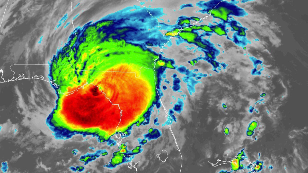
Hurricane Idalia makes landfall in Florida bringing dangerous impacts including heavy downpours, damaging winds and life-threatening storm surge.
Key Highlights
Threats: Heavy downpours, life-threatening storm surge, flooding, damaging winds, power outages, property damage, road closures, travel disruptions
Areas affected: FL, GA, SC, NC, AL
When: Monday, Aug. 28 - Sunday, Sept. 3
Hurricane Idalia makes landfall in Florida
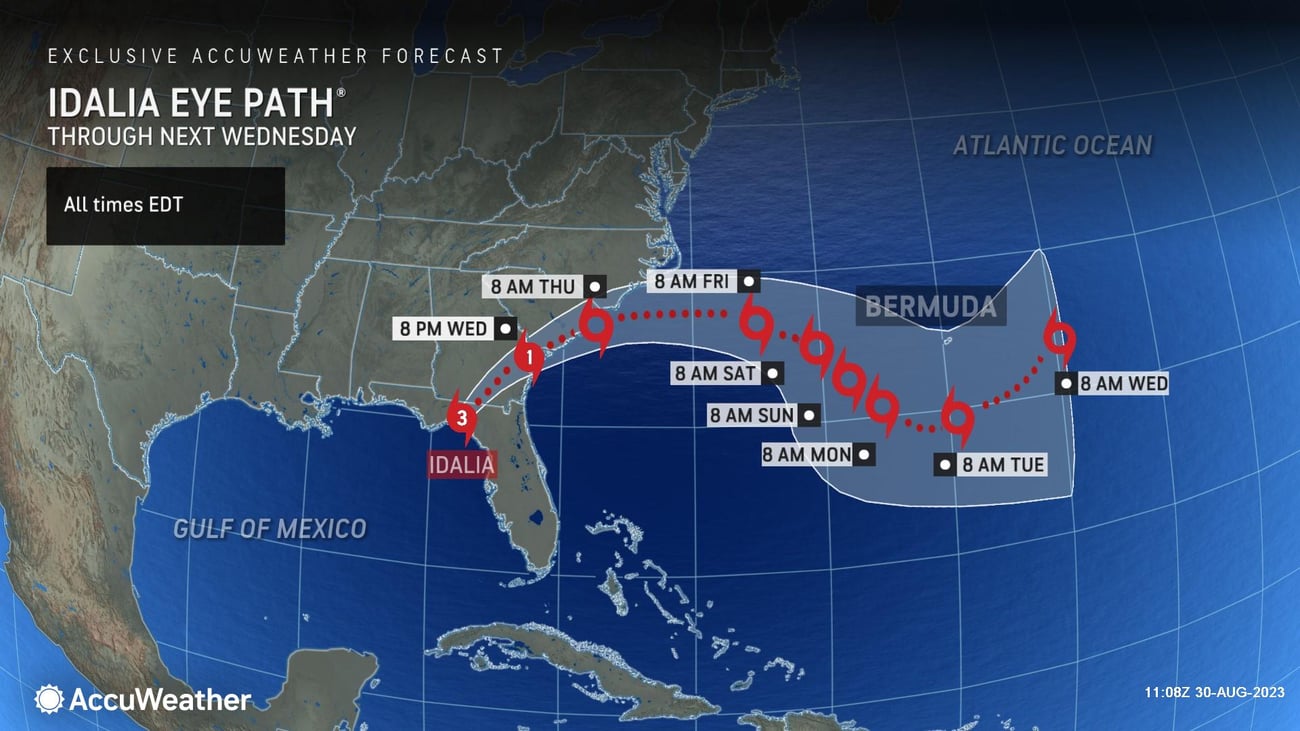
After issuing the first forecast for the storm more than 24 hours before any other source, AccuWeather's Hurricane Experts accurately predicted ahead of all other sources that Hurricane Idalia made landfall at Keaton Beach, Florida as a Category 3 bringing dangerous impacts. AccuWeather For Business is warning companies to continue to monitor the storm and to prepare for destructive impacts on operations.
Idalia's Trajectory and Potential for Major Hurricane Status
Hurricane Idalia Idalia lost some wind intensity as it neared Florida. Late Tuesday, Idalia had sustained winds peaking at 130 mph, the minimum wind speed required to be classified as a Category 4.
This will be an unprecedented event for areas around the Apalachee Bay. There has never been a major hurricane to move through the Apalachee Bay before in recorded history.
Impacts on Florida and Beyond
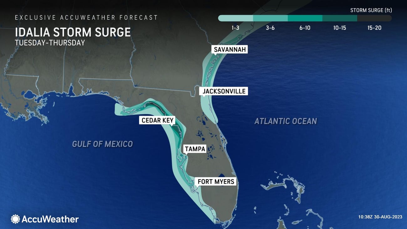
Businesses in Florida should closely monitor AccuWeather for updates on Idalia. AccuWeather meteorologists say a life-threatening storm surge will occur as the storm pushes inland, with surge levels above 15 feet possible. Due to the shape of the coast and the funneling effect this will have, a surge of this magnitude can cause potentially catastrophic destruction to the coastline which can permanently alter the shape of the coast..
Idalia's heavy tropical rain could result in flash floods, washing out roads and causing rivers and streams to rise. This might lead to travel problems and logistical issues in the area. Expect widespread damage to trees and power lines from strong winds. Where Idalia hits land, there could be significant structural damage.
Projected Rainfall and Wind Gusts
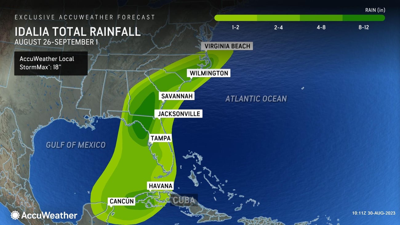
AccuWeather’s Expert Meteorologists warn businesses to expect up to 12 inches of rain will fall from north-central Florida up the southeastern coast to the Carolinas. There’s an AccuWeather Local StormMax™ of 18 inches.
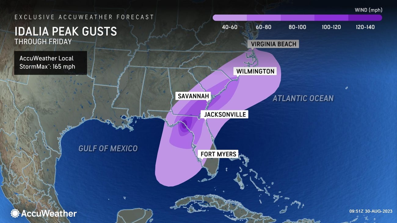
Wind gusts are expected up to 80 mph in the panhandle and northern Florida, extending to southern Georgia. More extreme gusts of up to 140 mph could lead to substantial damage to trees, power lines and structures. There is an AccuWeather Local StormMax™ of 165 mph.
Businesses in Florida and surrounding states will need to keep a close eye on this storm and should:
- Determine hazards your location is most vulnerable to during a hurricane
- Perform a vulnerability assessment of all equipment, processes and operations
- Prepare for winds and flying debris to cut power, which may not be restored immediately
- Stay away from floodwaters
Understanding the RealImpact™ Scale
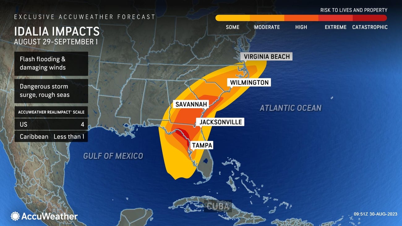
To understand the potential impact of Hurricane Idalia, it's important to look beyond just wind speed. Hurricane Idalia is a 4 on the AccuWeather RealImpact™ Scale For Hurricanes. This scale considers various factors including flooding rain, storm surge, economic damage and loss. This comprehensive approach allows for a better representation of the storm's potential impact on both lives and livelihoods. It's noteworthy that hazards like inland flooding and storm surges often result in more fatalities and economic losses than wind alone.
AccuWeather For Business can help companies and communities better prepare for hurricanes and keep their employees and customers safer.
Hurricanes are not just a problem along the coast; they can also impact businesses several hundred miles inland. Don't wait for an imminent hurricane or tropical storm to prepare your business for one. The message is clear: Start planning now.
An example of AccuWeather’s Superior Accuracy™, AccuWeather’s hurricane track forecasts are 3% more accurate than the National Hurricane Center and 13% more accurate in forecasting the intensity of hurricane winds along the path.
Want to learn more about how AccuWeather’s Hurricane Warning Service can help your business or community better prepare for tropical threats? Contact one of our experts today.
Join AccuWeather's experts for a free webinar, Be Prepared: 2023 Hurricane Season Update, on Thurs., Aug. 31, at 11 a.m. ET. REGISTER NOW to secure your spot.
The AccuWeather Advantage
AccuWeather's hurricane tracking is 3% more accurate than the National Hurricane Center and 13% more accurate on the intensity of the hurricane winds along the path. For example, AccuWeather was the only source to forecast a 16-20’ storm surge ahead of the disaster in Ft. Myers from Hurricane Ian that killed over 100 people. Our competitors predicted 12-16 feet, leaving many businesses in the path of that dangerous storm surge. Also, the forecasts from AccuWeather Hurricane Experts are often initiated well before the National Hurricane Center and any other source, updated more frequently, and have 14 unique layers describing impacts such as rainfall, wind gusts, the risk to lives and property that are exclusively made available by AccuWeather.
AccuWeather’s track record of Superior Accuracy™ in weather forecasting and warnings have saved our clients tens of billions of dollars, saved the lives of their employees and customers and minimized reputational harm. Throughout our 60+ year history, AccuWeather has saved over 10,000 lives and prevented injuries to over 100,000 people.
Serving more than half of the Fortune 500 companies and thousands of businesses globally, AccuWeather is recognized as the most accurate source of weather forecasts, advanced warnings and data in the world.


