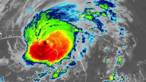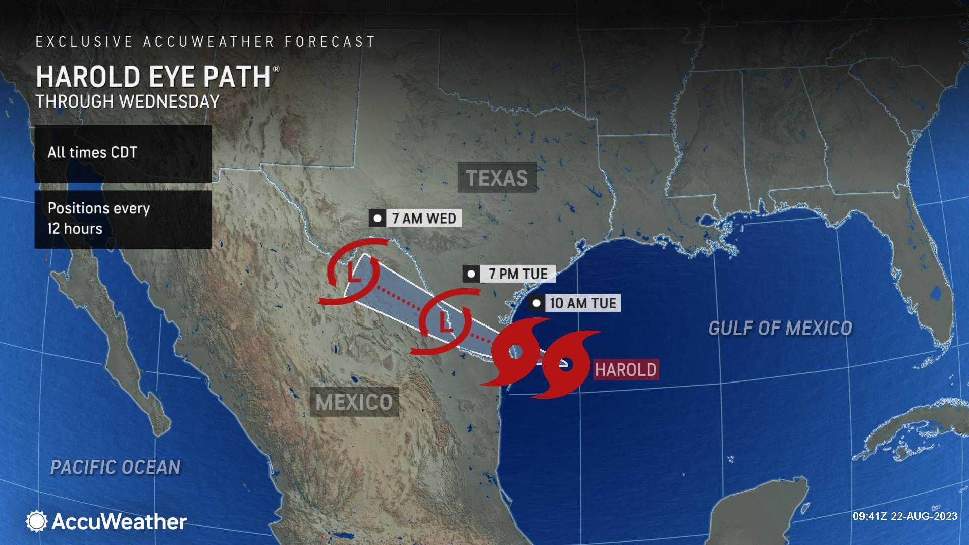
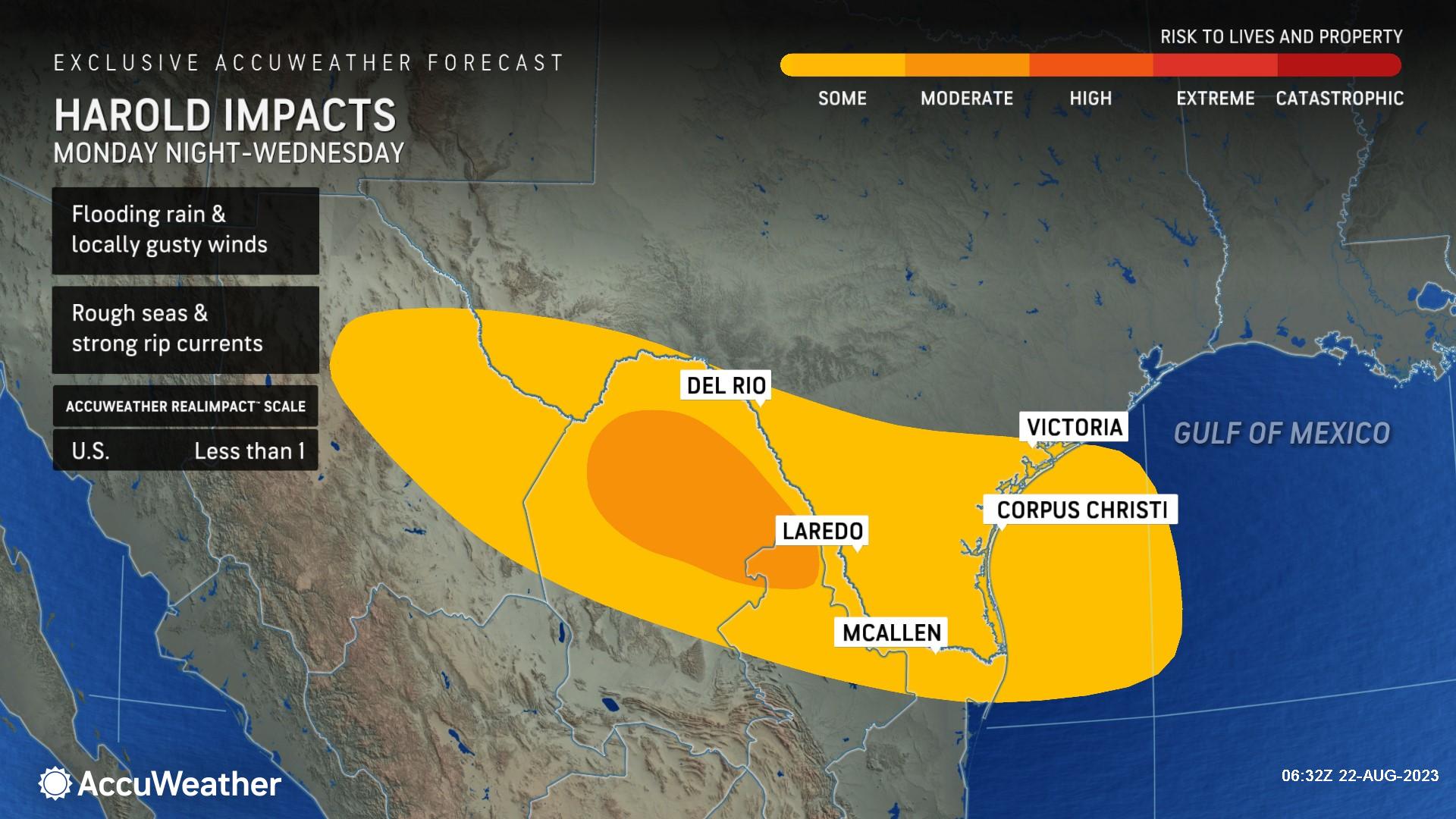
As meteorologists at AccuWeather have been predicting, a strengthening tropical system is moving toward South Texas. Tropical Storm Harold is located east-southeast of the South Texas coastline. Its projected path is towards the west-northwest, and it's expected to make landfall along South Padre Island, located southeast of Port Mansfield, Texas, Tuesday.
Hazards like inland flooding and storm surges threaten lives and property more than wind alone. As Tropical Storm Harold approaches, businesses must stay informed and prepared. AccuWeather For Business expert meteorologists provide the most accurate, detailed notifications of impending and imminent severe weather threats with forecasts backed by proven Superior Accuracy™.

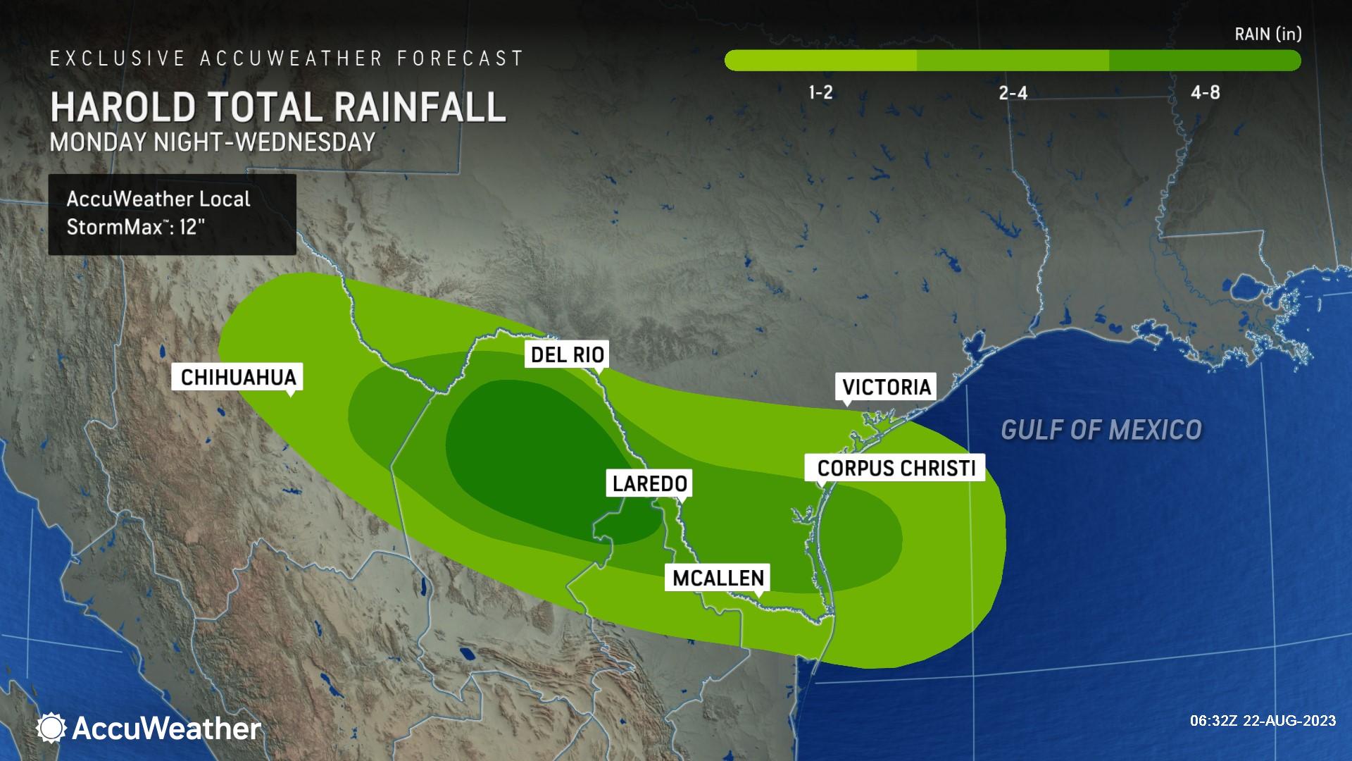
Rainfall outlook
The area will have heavy rainfall of up to 2 inches. A more concentrated band of rain of up to 4 inches will follow the track of Tropical Storm Harold. Some parts of northern Mexico might have higher rainfall totals of up to 8 inches. There is an AccuWeather Local StormMax™ of 12 inches.
The arrival of Tropical Storm Harold brings a mix of good news and challenges for South Texas. The region has been dealing with intense heat and persistent drought. The silver lining is that the storm's rain is a much-needed relief; however, the heavy rain could trigger flash floods, posing a potential threat to the area.
-1.jpeg?width=1920&height=1080&name=page%20(13)-1.jpeg)
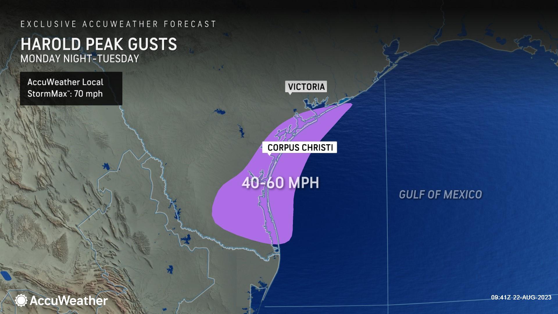
Winds and coastal impact
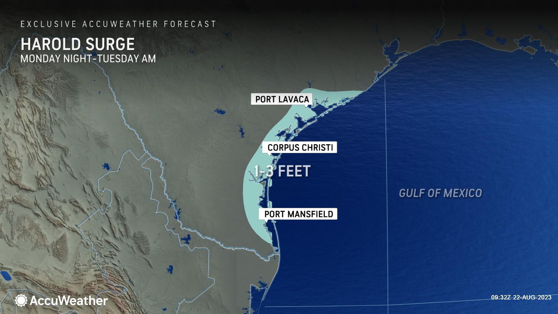
As the storm approaches, wind speeds will pick up along the South Texas coastlines. Wind Gusts up to 60 mph are likely, and there's a possibility of isolated higher gusts with an AccuWeather Local StormMax™ of 70 mph. These strong winds can potentially pile up water along the coastline, resulting in a storm surge reaching up to three feet. This, in turn, may lead to coastal flooding in areas stretching from Port Lavaca to Port Mansfield, Texas.
These strong winds can pile up water along the coastline, resulting in a storm surge reaching 3 feet. This, in turn, may lead to coastal flooding in areas stretching from Port Lavaca to Port Mansfield, Texas.
Risk of tornadoes and waterspouts
AccuWeather's hurricane experts are also warning businesses about the threat of potential tornadoes and waterspouts. Companies and communities in Harold’s path should prepare for these risks, AccuWeather For Business clients should watch for AccuWeather SkyGuard Warnings.
>>READ MORE: Better prepare your business for the impacts of hurricane season
AccuWeather RealImpact™ Scale for Hurricanes
While approaching with some intensity, Tropical Storm Harold is categorized as a less than 1 on the AccuWeather RealImpact™ Scale for Hurricanes. This scale offers a different perspective than the traditional Saffir-Simpson Hurricane Wind Scale. Instead of solely focusing on wind speed, the AccuWeather RealImpact™ Scale considers a wider array of factors that contribute to the overall impact of a storm. This includes flooding rain, storm surge, and potential economic damage and loss.
Prioritizing Safety and Preparedness with AccuWeather For Business
Businesses in Texas and surrounding states will need to keep a close eye on this storm as it approaches and should:
- Determine hazards your location is most vulnerable to during a hurricane
- Perform a vulnerability assessment of all equipment, processes and operations
- Prepare for winds and flying debris to cut power, which may not be restored immediately
- Stay away from floodwaters
AccuWeather For Business can help companies and communities better prepare for hurricanes and keep their employees and customers safer.
AccuWeather's hurricane tracking is 3% more accurate than the National Hurricane Center and 13% more accurate on the intensity of the hurricane winds along the path. Also, the forecasts from AccuWeather Hurricane Experts are often initiated well before all other weather providers. These forecasts are more accurate and updated more frequently and have 14 unique layers describing impacts such as rainfall, wind gusts, and the risk to lives and property that are exclusively made available by AccuWeather.
Hurricanes are not just a problem along the coast; they can also impact businesses several hundred miles inland. Don't wait for an imminent hurricane or tropical storm to prepare your business for one. The message is clear: Start planning now.
Want to learn more about how AccuWeather’s Hurricane Warning Service can help your business or community better prepare for tropical threats? Contact one of our experts today.

Join AccuWeather's experts for a free webinar, Be Prepared: 2023 Hurricane Season Update, on Thurs., Aug. 31, at 11 a.m. ET. REGISTER NOW to secure your spot.
Bring your questions. There will be a live Q&A portion.
Can’t attend, no problem. We’ll send you a recording of the presentation.

The AccuWeather Advantage
AccuWeather’s track record of Superior Accuracy™ in weather forecasting and warnings have saved our clients tens of billions of dollars, saved the lives of their employees and customers, and minimized reputational harm. Over the course of our 60+ year history, AccuWeather has saved over 10,000 lives and prevented injuries to over 100,000 people.
Serving more than half of the Fortune 500 companies and thousands of businesses globally, AccuWeather is recognized as the most accurate source of weather forecasts, advanced warnings, and data in the world.