Major winter storm could morph into a bomb cyclone bringing blizzard conditions, heavy snow, and bitter cold across the U.S.
Summary
Businesses should prepare for business disruptions, and logistical issues as a massive storm and dangerously cold conditions sweep the U.S. ahead of the holiday weekend.
Key Highlights
Threats: extreme cold, heavy snow, gusty winds, heavy rain, travel delays, power outages
States affected: The entire U.S.
When: Wednesday, December 21 - Sunday, December 25
ARCTIC AIR MASS COLD WILL CREATE THE COLDEST TEMPERATURES AHEAD OF CHRISTMAS IN DECADES
AccuWeather's expert meteorologists are keeping a close eye on an arctic cold mass that will create dangerous conditions across the U.S. from mid to late this week. The arctic air mass is threatening the coldest lead-up to the Christmas holiday in decades. The explosive strengthening of the system could result in a bomb cyclone, not only bringing below-freezing temperatures but also blizzard conditions and heavy snow across the country. The system could create logistical issues as this week is busy for customers finishing up shopping and businesses looking to boost workflow and sales before the holiday weekend.
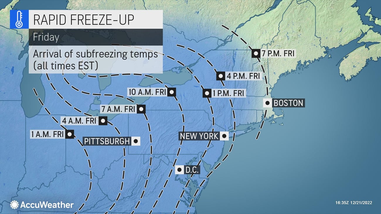
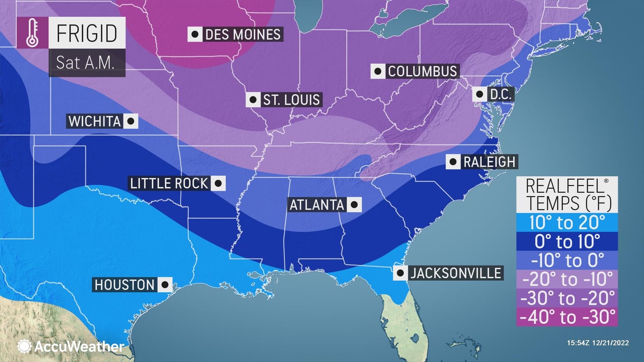
Behind the front, temperatures will plunge by 20-50 degrees in only 24 hours, heading well below zero across the Rockies, Plains, and Upper Midwest, with single digits in some areas by the end of the week. There's concern about a hard freeze in Texas, Louisiana, Mississippi, Alabama, and Georgia that could threaten pipes. The frozen temperatures will threaten the orange crop in central Florida.
Before the holiday weekend, freezing temperatures are also possible across northern and central Florida. The bitter cold can spike energy demands or change your outdoor plans because of the extreme cold.
>> FOLLOW US on LinkedIn for essential weather updates that could impact your business.
Snow removal can also become more difficult due to the extreme cold. Compacted snow can turn into sheets of ice on roads, and traditional salt becomes far less effective with temperatures in the teens and colder.
Businesses should be prepared for the frigid temperatures and expect the following:
- An increased risk of fire activity due to drier air combined with heating sources and/or manufacturing processes
- Sickness is one of the top cold-weather risks for small businesses and can have a disastrous effect on productivity.
- Insulate pipes and leave taps dripping; review business insurance policies to ensure you're covered for cold-weather incidents, including damage to property and inventory.
MIDWEST, GREAT LAKES SET TO SEE HEAVY SNOW, BLIZZARD CONDITIONS
AccuWeather expert meteorologists are also keeping a close eye on the potential for a massive storm system that can bring accumulating snow and blizzard conditions ahead of the holiday weekend to The Great Lakes region.
>>MORE DETAILS: Massive storm could impact holiday, business travel at the worst possible time
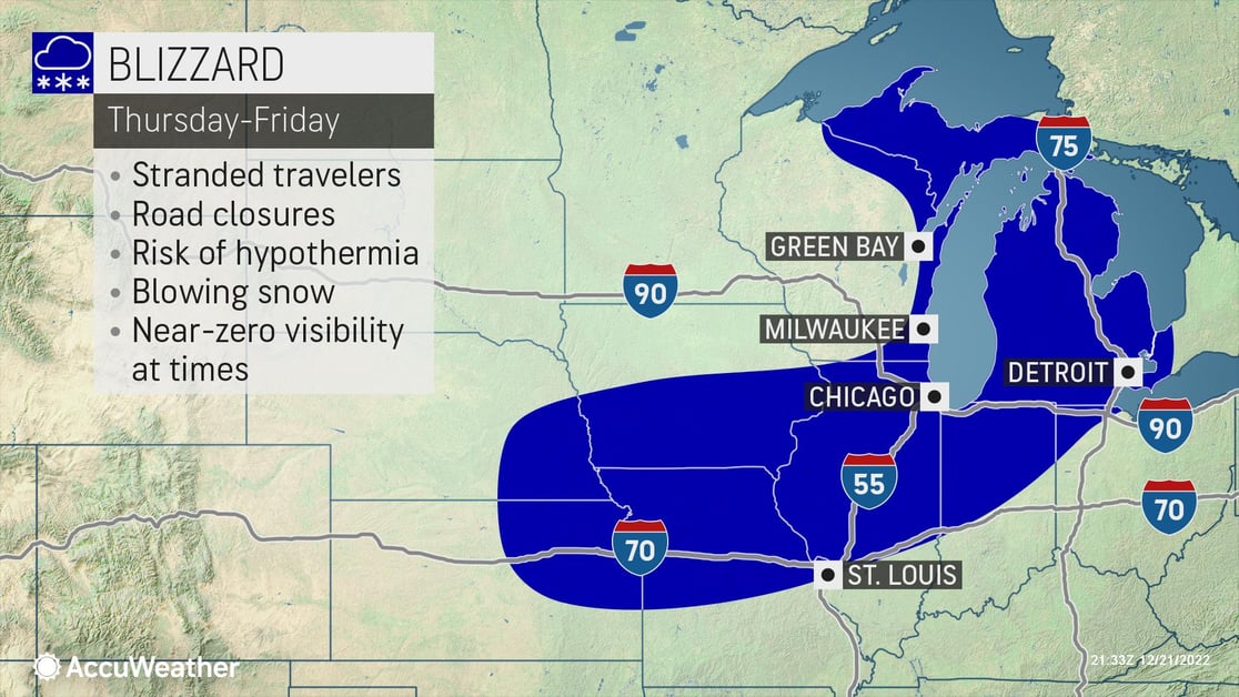
AccuWeather forecasts there can be a 1500-mile stretch at risk for blizzard conditions, with falling or blowing snow with winds of at least 35 mph reducing visibility to a quarter mile or less for at least three hours, with this intense winter storm from parts of Central Kansas to northwestern Quebec in Canada, according to AccuWeather Chief Meteorologist Jonathan Porter.
>>MORE DETAILS: What is a bomb cyclone?
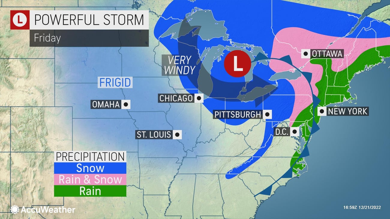
Blizzard conditions are most likely from the central Plains through the Midwest and into the central Great Lakes. Several inches of snow is expected to blow around, reduce visibility, and make travel extremely dangerous from Thursday to Friday.
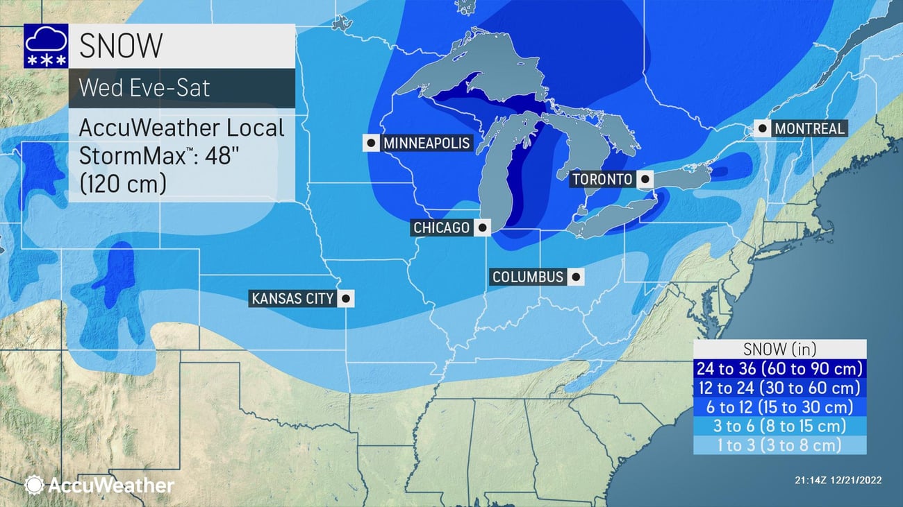
Across some of the highest peaks of the Rockies, an AccuWeather Local StormMax™ of 36 inches of snow is expected. Depending on location, many lower-lying valleys can expect 1-3 or 3-6 inches of snow. Across the higher mountainous terrain, snowfall totals can approach a foot across portions of Montana, Wyoming, Utah, and Colorado.
Accumulations of up to 3 inches are expected in the southern Plains, middle Mississippi River Valley, and into the Ohio River Valley later this week. Higher snowfall totals of up to 12 inches are expected further north in the Midwest and Great Lakes. More than a foot of snow is expected to fall in lake-effect zones. Within the zone of lake-enhanced snowfall, an AccuWeather Local StormMax™ of 48 inches is expected.
Across the Northeast, accumulating snow can come in two waves, with the first round beginning at the onset of the storm Thursday into Thursday night. A surge of milder air can transition snow to ice and rain in spots Thursday night into Friday as a powerful cold front sweeps through. Rain can transition back over to snow between Friday and Friday night.
Businesses in the path of this major storm should prepare for the following:
- Retail: Shovel and salt walkways, dry high-traffic areas inside near your entrance, and keep all floors clear to help prevent falls and reduce liability.
- Business interruptions due to extended power outages.
- Ground logistics disruption from drifting snow, downed trees, and power outages due to road closures.
- Prioritize cold weather concerns for outdoor workers.
Protect your business and team members by making the best weather-impacted decisions with AccuWeather's Snow Warning Service, backed by forecasts and warnings with Superior Accuracy™. AccuWeather's Snow Warning Service offers location-specific forecasts and 24x7x365 consulting services for snow, ice, blizzards, and other winter-hazard events.
AccuWeather's Snow Warning Service features include:
- Precise weather event start and end times
- Total expected snow and ice accumulations
- Specific changeover times for snow, ice, and rain
- Hourly temperatures and wind conditions before, during, and after the storm
- Post-storm weather conditions, including verified precipitation amounts.
Subscribe to our AccuWeather for Business Blog for the latest news and weather updates that will impact you and your business.
THE MOST TRUSTED AND RECOGNIZED NAME IN WEATHER
Serving more than half of Fortune 500 companies and thousands of businesses globally, AccuWeather is recognized as the most accurate source of weather forecasts, warnings, and data in the world.


