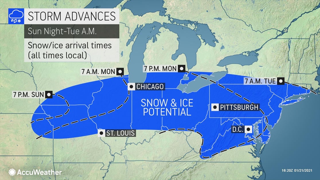
AccuWeather meteorologists are monitoring the potential for a disruptive winter storm in portions of the Plains, Midwest, Middle Atlantic and southern New England starting this weekend.
Snow
Early next week, heavy snow and ice will impact states from the Midwest through the Northeast. Snow will begin across portions of the Midwest overnight on Sunday, the Ohio Valley on Monday morning, and the Northeast by Monday afternoon.
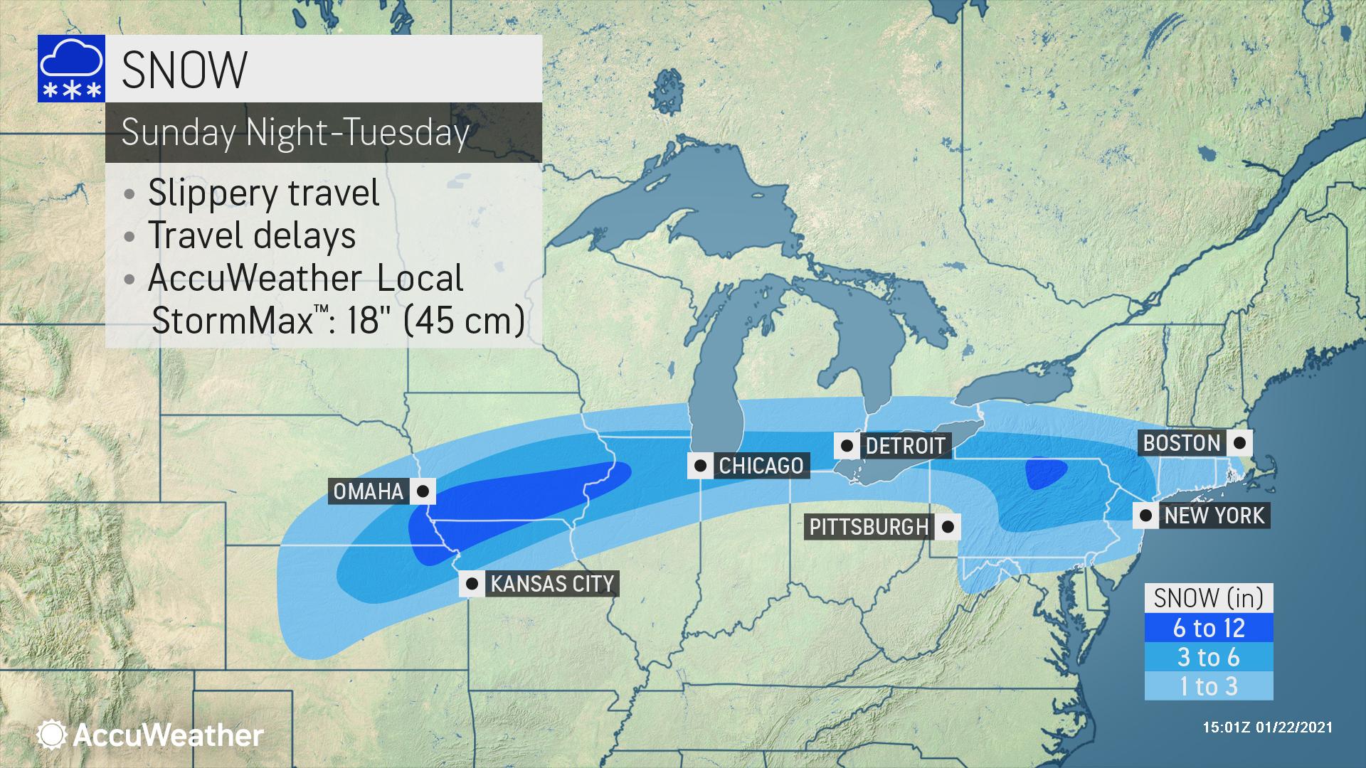
The heaviest snow of 6-12 inches falling at rates of 1"per hour will occur across the middle Mississippi Valley and central Pennsylvania. Snowfall amounts of 3-6 inches falling at rates of 0.75"per hour will occur across the Lower Great Lakes, through Pennsylvania, and to the I-95 corridor. Look for snow to taper off across the Midwest by Monday evening and the Ohio Valley Monday night. Snow will continue into Tuesday across the Northeast with future updates reflecting additional snowfall.
Freezing Rain
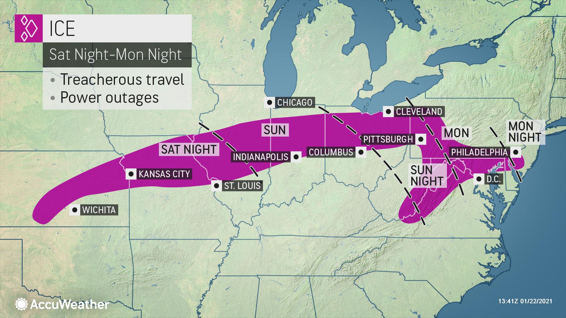
Freezing rain will accompany the southern extent of the snowfall early next week. Look for freezing rain to begin across southern portions of the Midwest overnight on Sunday and the Ohio Valley and Northeast by Monday morning. The highest icing totaling 0.25-0.50 inches will occur across southwest Pennsylvania through the Central Appalachians. Freezing rain will diminish across southern portions of the Midwest on Monday evening and the Ohio Valley into Northeast by Tuesday morning.
The storm’s track and strength will have big implications on who experiences snow and ice accumulation, and our meteorologists see two scenarios. The first is a more southern track which would mean a much smaller area of snow and ice that spares much of the lower Great Lakes (like Chicago, Detroit and Cleveland) from being impacted, as well as areas north of Washington, D.C., and Baltimore. The second is a more northern track which would not only mean a stronger storm, but a larger area of snow and ice that could spread as far north as central Michigan, upstate New York and southern New England. While more locales will get snow and ice, the more northerly track would likely mean a changeover of snow or ice to rain as far north as parts of Pennsylvania and New Jersey.
Stay up-to-date this winter with a demo of SkyGuard® weather risk platform for business.
- Expect ground logistics disruption and travel delays due to road and interstate closures, especially along I-95
- Protect your company against liability risks by ensuring any employees driving in bad weather on company time are trained in safe, cautious driving techniques and know the actions to take in the event of an accident
- Heavy snow and ice accumulating on tree branches as well as power lines may lead to downed trees and power outages and ultimately business interruption
- Structure stress and damage can occur due to heavy snow load