AccuWeather forecasters warn of potential derecho for Midwest, mid-Atlantic
Summary
Widespread, damaging severe storms expected to impact the Great Lakes and Mid-Atlantic could merge into a powerful weather phenomenon known as a derecho.
Key Highlights
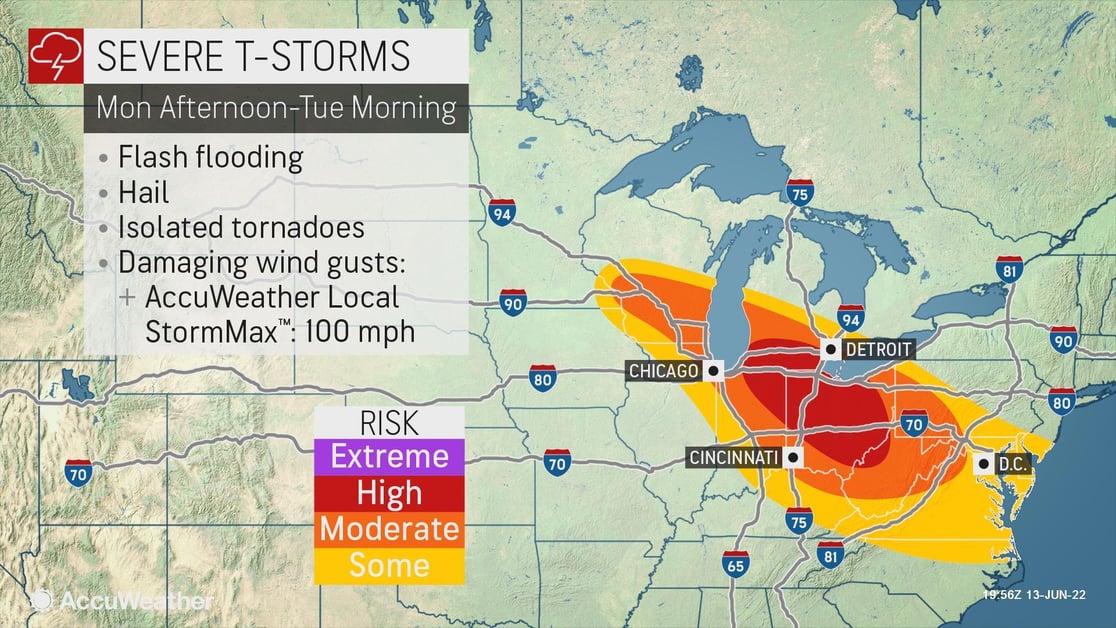
Threats: Damaging wind gusts: AccuWeather Local StormMax™ of 100mph, flash flooding, hail, frequent lightning, isolated tornadoes
States affected: WI, IN, MI, OH, KY, PA, WV, VA, MD, D.C., NJ, DE
When: Monday, June 13 - Tuesday, June 14
AccuWeather For Business meteorologists are forecasting potentially damaging storms that will pack high winds and torrential rain from southeastern Wisconsin and western Michigan to Virginia and Maryland spanning Monday to Tuesday. Storms will fire on the northern and northeastern rim of intense heat and high humidity that is roasting the Plains and Mississippi Valley.
The atmosphere is primed for a significant damaging wind risk through at least Monday night. With a sharp temperature contrast over the Great Lakes between expanding, record-setting heat to the south and much cooler and less humid air to the north, thunderstorm clusters tend to intensify and thrive moving along such a boundary.
Unique storm attributes to intensify wind risk
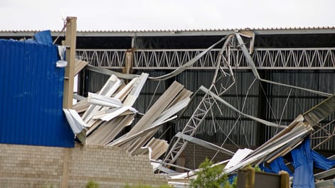
This severe thunderstorm complex is unique because the threat for wind damage is much more widespread than what usually occurs with most severe thunderstorms. Typically, severe thunderstorm wind damage tends to be much more localized to a part of a community, whereas this cluster of thunderstorms may create damage over a much larger area.
This is especially concerning because some of the areas at greatest risk for damage from this thunderstorm cluster will be impacted by high temperatures in the coming days. For example, AccuWeather RealFeel® Temperatures will be around 100 in lower Michigan and Ohio on Tuesday and Wednesday.
High possibility for a derecho
There is the potential for thunderstorms to organize into a large complex and then reach the threshold of a derecho, a high-powered severe weather event in which wind gusts reach or exceed 58 mph along an area of 240 miles or greater. The National Weather Service (NWS) makes the determination as to whether or not a long-lived thunderstorm complex reached the criteria for a derecho, usually after the event has concluded.
Our business weather experts have experience with forecasting derechos accurately. Learn how we provided our clients accurate, actionable warnings for winds up to 100 mph, 30-60 minutes before the Iowa derecho hit on August 10, 2020.
Areas of concern
Locations along a corridor from central Wisconsin through northern West Virginia are expected to be at the greatest risk of severe weather from this system, with widespread gusts over 70 mph possible with an AccuWeather Local StormMax™ of 100 mph. This is the area where AccuWeather meteorologists feel there is the greatest threat of a derecho.
The storms will be firing up and are likely to first hit Milwaukee and the Chicago metro area late Monday afternoon before moving on to part of the Detroit metro area and perhaps blasting right through Columbus, Ohio, Monday night.
There are some questions as to the path, longevity and extent of the thunderstorm complex, but there is no doubt of the likelihood of at least isolated severe storms over hundreds of miles.
Regardless of an official designation of a derecho or not, severe thunderstorms are likely to occur along a swath of 700 miles from the Great Lakes region during late Monday and Monday night to portions of the central Appalachians early Tuesday morning. One or more lines of storms may extend all the way to the Chesapeake Bay region.
Additional storm threats
With these storms, there is the risk of frequent lightning strikes, large hail, isolated tornadoes and flash flooding. Heavy rainfall could produce 2-3 inches in a short period of time, elevating the risk for rapidly rising water, including flooding of creeks and streams as well as roadways, especially in areas already saturated from recent rainfall.
Once the thunderstorm complex develops, it could begin to move at a forward speed of 40-60 mph. Storms tracking at this speed could allow just a few minutes to take shelter after the first rumbles of thunder and flashes of lightning are observed.
Businesses with weather exposure in these areas should monitor this system closely and keep life safety and asset protection top of mind.
- Refresh tornado sheltering options and brief employees on actions to be taken should a tornado occur. Storm shelters should be well-marked and equipped with a disaster supply kit
- Expect loss of inventory due to flooding - If your warehouse is in a low-lying area, precautions should be taken
- Business interruption due to extended power outages can be expected
- Ensure all employees and visitors on-site have a way to be notified of severe weather
- Take precaution with securing outdoor equipment due to high winds
- Damaging hail could impact outdoor activities, equipment and inventory
- Expect ground logistics disruption due to road closures, downed trees and other obstacles
- Ground stops are likely at area airports as the storms approach
Stay safe with SkyGuard®Warnings:
- Proactive, site-specific alerts offer advance warnings well before severe weather impacts occur
- Live one-on-one or group consultation is provided by our weather experts anytime, day or night
- Reviewed tornado notifications advise when a government-issued tornado warning is in effect but there is no threat to your asset location
- Alerts are delivered in a format that aligns with your organizational emergency management plan
- All-clear notifications are delivered when a threat is over, minimizing weather-related downtime
- All alerts are delivered via push notification from the SkyGuard mobile app, available on Android and iOS