Hurricane Beryl
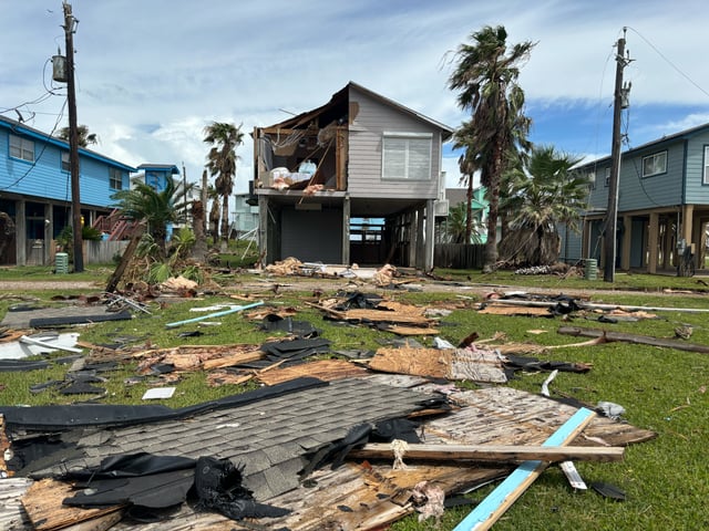
June 28 – July 11, 2024: On July 2, 28 hours before the NHC and any other known source, AccuWeather predicted Beryl would bring flooding and damaging winds to Texas.
AccuWeather Outperforms National Hurricane Center and All Other Known Sources in 2024 Hurricane Season With Most Accurate Forecasts, Most Advance Notice, according to a study done by Kantar*.

AccuWeather provides more frequent updates as the storm approaches and threatens your particular area. Importantly, our forecasts and warnings are pinpointed to your exact location and include details of the hurricane's impact on your jurisdiction, whether it’s storm surge, flooding rains, the risk of wind damage, or tornado development—all tailored to your precise location and your particular needs.
AccuWeather's Hurricane Experts are watching and monitoring your community 24/7/365, and they are available for live consultations with you whenever you desire, especially when you are on the verge of important decisions. AccuWeather’s AssetReport™ will change how you and your organization react to hurricane threats this storm season. Whether you’re protecting a single asset or thousands, our end-to-end solutions provide the insights you need to enhance safety and reduce risk before, during, and after the storm.
AccuWeather's Hurricane Warning Service's exclusive benefits:
|
|
|
|
|
|
|
|
AccuWeather For Business hurricane impact-driven warnings and forecasts provide organizations worldwide with a single, accurate source of information when hurricanes threaten. All products are displayed on the intuitive AccuWeather For Business Portal and SkyGuard® Companion App. Use our Superior Accuracy™ to make the best decisions to enhance safety and reduce risk and liability.

Get key details on expected hurricane track and impacts emailed to you whenever we have important updates to share. Our meteorologists prepare hurricane forecasts independently of the government, and our forecasts are issued ahead of any other source, giving you a head start in preparation. Once a storm approaches the coast, Impact Forecasts become more frequent and offer greater detail, allowing a more granular look at actual impact per asset location.

Layers include watches and warnings, storm surge, rainfall, maximum wind gusts, probability of hurricane-force winds, and more. With the AccuWeather For Business Portal, you won’t have to guess what impacts will affect which areas – the specifics are clearly presented based on our own forecasts. Unique to the Portal is our detailed forecast track, drawn and adjusted by expert meteorologists. Additionally, our proprietary risk assessment layer provides an impact-based evaluation for all expected hazards and hurricane factors, including the time of year, societal, infrastructure, recent rainfall, and more. The Portal displays forecasts up to 7 days in advance.

Created by our lead hurricane meteorologist and distributed daily by email, this report contains expert tropical commentary accompanied by detailed maps for the Atlantic and Eastern Pacific basins, including potential areas for development, as well as storm tracks. Use this daily update to be the first to know about possible tropical storm development and risk areas. Long-range forecasts for western Pacific and Australian basins are also available.


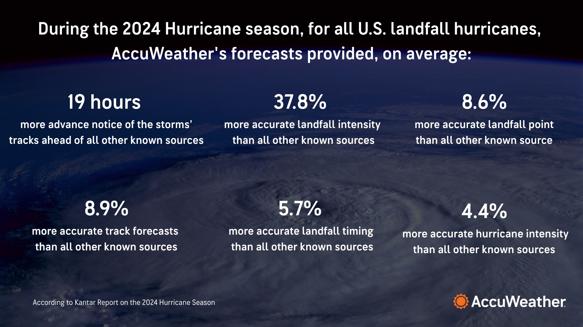
A new study conducted by Kantar, one of the world’s leading marketing data and analytics companies, has found that AccuWeather provided the most accurate and most effective hurricane forecasts during the 2024 Atlantic hurricane season, outperforming the National Hurricane Center (NHC) and all other known sources.
For all 2024 U.S. landfall hurricanes, AccuWeather's forecasts provided, on average, 19 hours more advance notice of the storms’ track, 8.9% more accurate track forecasts, 4.4% more accurate hurricane intensity forecast, 5.7% more accurate landfall timing, 8.6% more accurate landfall point, and 37.8% more accurate landfall intensity forecast. >> Read the Full Report Here

June 28 – July 11, 2024: On July 2, 28 hours before the NHC and any other known source, AccuWeather predicted Beryl would bring flooding and damaging winds to Texas.

September 26 – 27, 2024: On September 24, AccuWeather was the ONLY known source to accurately warn that Helene would bring a catastrophic "flooding disaster” to the Southern Appalachians. And we did it 48 hours in advance.

October 5 - 10, 2024: On September 27, 12 days before Milton developed, AccuWeather was the first known source to predict that a tropical storm or hurricane would track towards Florida. On October 5, 6 hours before the NHC and all other known sources, AccuWeather issued its first track.

September 23 – 30, 2022: AccuWeather issued a track three days before the NHC. AccuWeather predicted a lethal storm surge of 16-20’ and the NHC predicted 12’-16’. AccuWeather saved dozens of lives as the storm surge of 18’ hit Florida and killed 150 people.

October 22, 2012 – November 2, 2012: AccuWeather was the first to notify the public and save lives with warnings that were days ahead and more accurate than any other source. While the government and other public sources of information declared that Sandy would “not be a hurricane” at landfall, AccuWeather continued to call it a hurricane, knowing that people take action more critically for a hurricane than for more standard wind and coastal flood warning.

August 23, 2005 – August 31, 2005: AccuWeather was cited by U.S. Congress as the first and only source to forecast the storm’s full damage in advance, saving an estimated ten thousand lives.
“AccuWeather was my go-to app for information on Hurricane Ian as it approached Florida's Gulf Coast, and it was invaluable. The media frenzy around Hurricane Ian was at times contradictory and often vague. As I live in Evacuation Zone A in Bradenton, Florida, I needed an accurate weather app. As the hurricane drew closer, I used AccuWeather as my single source for the changing conditions of the storm.
“In Florida, self-preservation in a hurricane is a personal responsibility. Governments can issue mandatory evacuations and open shelters, but the responsibility for actual survival rests with the individual. Because of Ian's wobble, I tracked the storm using AccuWeather as the weather deteriorated. Using your Hurricane Tracking, I determined a point at which evacuation was critical to survival.
“Since my wife and I have two dogs and a cat, we can't just jump in the car and flee. My own point of evacuation was just prior to Ian's east turn. Once that happened, we decided to hide from the wind, since we didn't have to run from the water. We endured hours of exceptionally strong winds, but other than the landscape vegetation, we had no damage or injuries, even though we live 50 yards from the bank of the Manatee River.
“In retrospect, using AccuWeather tracking, we avoided fleeing east too early. Had we done that, we would have been stranded right in the hurricane's path with no options.
“Before the storm clouds cleared, I bought a year's subscription to AccuWeather, and it is now part of my hurricane survival kit. AccuWeather provided me with the information I needed to make an informed, critical survival decision in a potentially deadly scenario. Thank you for your service.”
SEPTEMBER 2022 - HURRICANE IAN
AccuWeather App User
“I wanted to thank AccuWeather for the great job y’all did. This thing was forecast ‘right on the money.’ Fast-moving and powerful. That’s the forecast we gave everyone the day before, and you were right on target with this.”
November 2020 - Hurricane Zeta
Government official in Mississippi
"During our school district’s preparations for the possible arrival of Hurricane Dorian, we asked if AccuWeather could provide our leadership team with a forecast and briefing. Having been on several conference calls with other government groups and weather experts we found that the AccuWeather information was the most useful and easy for non-weather staff to understand. It was by far the best Hurricane Dorian briefing I sat in on.”
“I just wanted to let you know how much I appreciate the accuracy of your hurricane forecasts. During Dorian. I watched the Weather Channel for about 5 minutes at a time and got tired of all the hype, everything was catastrophic, record-breaking, killer, deadly, I am sure you get the idea. Your forecast cones were extremely accurate, way better than National Hurricane Center cones, which were huge in area. My daughter lives in southeast Georgia and was terrified by what she was seeing. I started sending her copies of your forecast cones and she was able to prepare for a possible event with much more calmness. Your app on my smartphone is a Godsend! Thanks so much!!!!”
AUGUST 2019: HURRICANE DORIAN
School and business leaders
