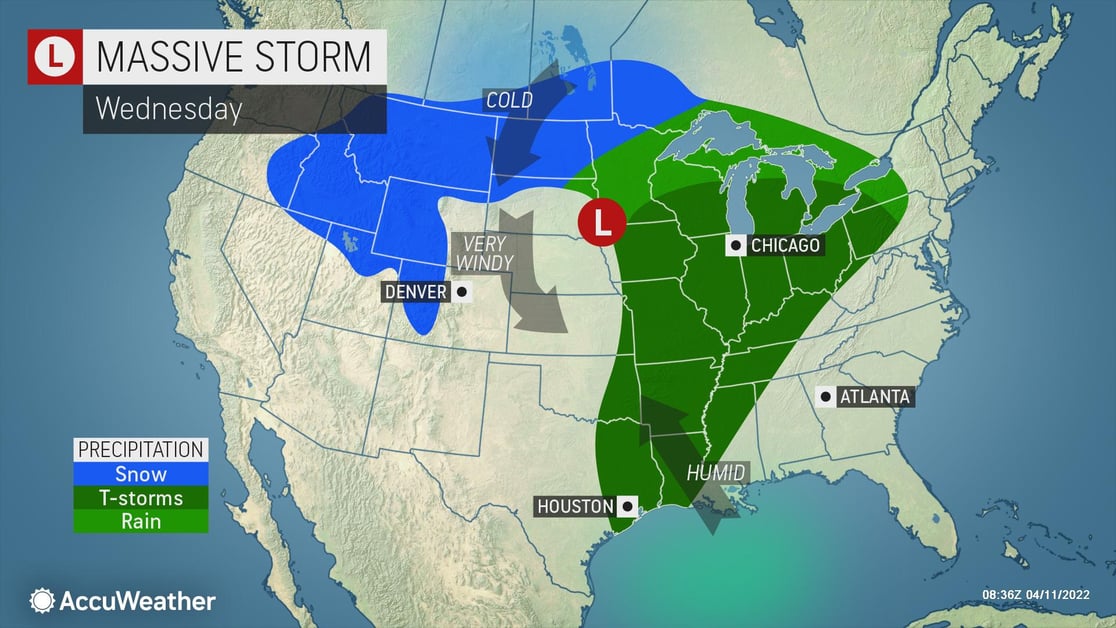
A Storm of Trouble
AccuWeather For Business meteorologists are monitoring the development of a large storm moving from the Northwest through the Plains this week. As the storm moves into the northern Plains, it is forecast to strengthen, bringing widespread gusty winds and blizzard conditions to the area. It will also impact communities from the southern Plains to the Mississippi and Ohio River valleys, bringing dangerous severe weather, including tornados, damaging winds, and hail, over the next several days.

The threat for severe weather begins Monday, impacting northern Texas to the Ozarks. Large hail, isolated tornadoes, and flooding downpours will impact the area, along with an AccuWeather Local StormMax™ of 80 mph wind gusts. The severe weather threat will be more widespread on Tuesday and Tuesday night, extending from southern Minnesota southward to central and eastern Texas. Tornadoes, damaging winds, and flash flooding are all forecasted. This will continue Wednesday into southern Wisconsin and southwestern Michigan southward to the central Gulf Coast. Tornadoes will remain a major threat, along with large hail, flash flooding, and damaging winds for major cities like St. Louis, Chicago, New Orleans, and Nashville. For wind, there is an AccuWeather Local StormMax™ of 80 mph.

Businesses in the area need to keep a close eye on this system and should:
- Expect business interruption due to power outages
- Disruptions to ground logistics due to road closures and icy/snow-covered roads
- Prioritize cold weather concerns for outdoor workers
- Ensure all employees and visitors on-site have a way to be notified of severe weather
When severe weather strikes - Partner with us
Trust our experts to help you make critical decisions with confidence whenever snow and ice threaten, starting with AccuWeather Snow Alerts™ delivered straight to your inbox. Take a step up with 1:1 business weather expert support with our Snow Warning Service. Or cover everything you need around the globe in all types of weather with SkyGuard® Severe Weather Warnings.